GEOLOGY - THE SCIENCE OF THE SOLID EARTH AND ITS INTERNAL PROCESSES, INFLUENCED ALSO BY THE ATMOSPHERE, OCEANS/RIVERS, AND BIOLOGICAL ACTIVITIES - COMES FROM THE GREEK WORDS GEOS (EARTH) AND LOGOS (STUDY). PLANETOLOGY INVOLVES ON-SITE AND SENSOR INVESTIGATIONS OF THE OTHER SOLAR (AND NOW EXTRASOLAR) PLANETARY BODIES, USING MAINLY COMPARISONS TO TERRESTRIAL GEOLOGICAL FEATURES AND PROCESSES AND APPLYING METHODS OF ANALYSIS PROVEN EFFECTIVE FOR EARTH STUDIES.
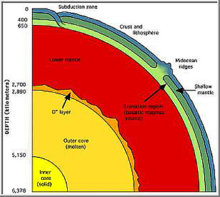
1. The Earth formed about 4.6 billion years ago, along with the other solar planets and the Sun itself. The planets built up by accretion of rocky and gaseous debris (asteroidal, planetesimal [meteoritic] materials and comets) through collision of orbiting bodies. Aided by gravitational attraction which helped to compact these material, early on the assembling Earth underwent partial to complete melting, separation of different materials into an inner and outer core (Iron-Nickel), an extensive interior mantle, (Iron/Magnesium/Calcium-rich silicates), and a thin crust (enriched in Silica, Sodium/Potassium/Aluminum), all (except the outer core) solidifying by cooling over the first few hundred million years; escaping gases produced an atmosphere (principaly H, CO2, N, CH4) were held above the solid Earth by gravity owing to its large mass; in time (about 4 billion years ago), the Earth's exterior cooled sufficiently to allow vast volumes of water vapor to condense, forming in lower areas great concentrations of water collected into depressions (oceanic basins).
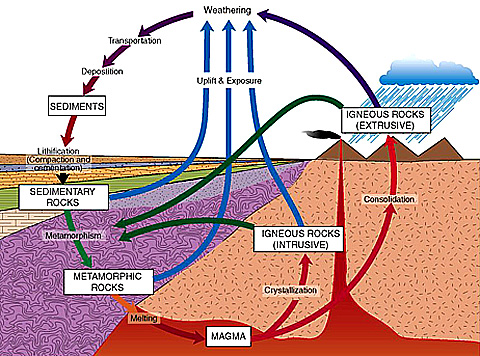
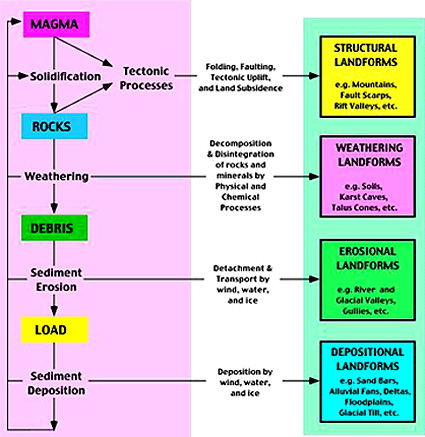
2. The Earth's materials are diverse and variable. Most variation occurs in the outermost 200 kilometers, in the lithosphere. Igneous rocks form directly by crystallization of hot melts made up of silicates (SimOn) combined with Fe, Mg, Ca, Al, Na, K, Ti, H2O). Minerals formed from these make up nearly all the mantle and crust. Rocks at the surface decompose/disintegrate by reaction with the atmosphere/hydrosphere to produce solid debris and soluble chemicals that are transported/deposited to form sediments, that upon burial are converted to Sedimentary rocks (usually layered; strata). Previously formed rocks that are heated and pressurized when buried to shallow to moderate depths (5 to 70 km) of the crust recrystallize as solids under increased temperatures and pressures to form Metamorphic rocks (some may melt). The above processes comprise the Rock Cycle, shown below, and discussed in more detail on this page.
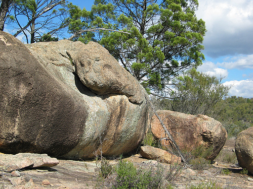
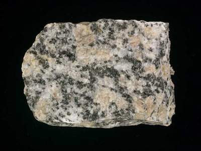
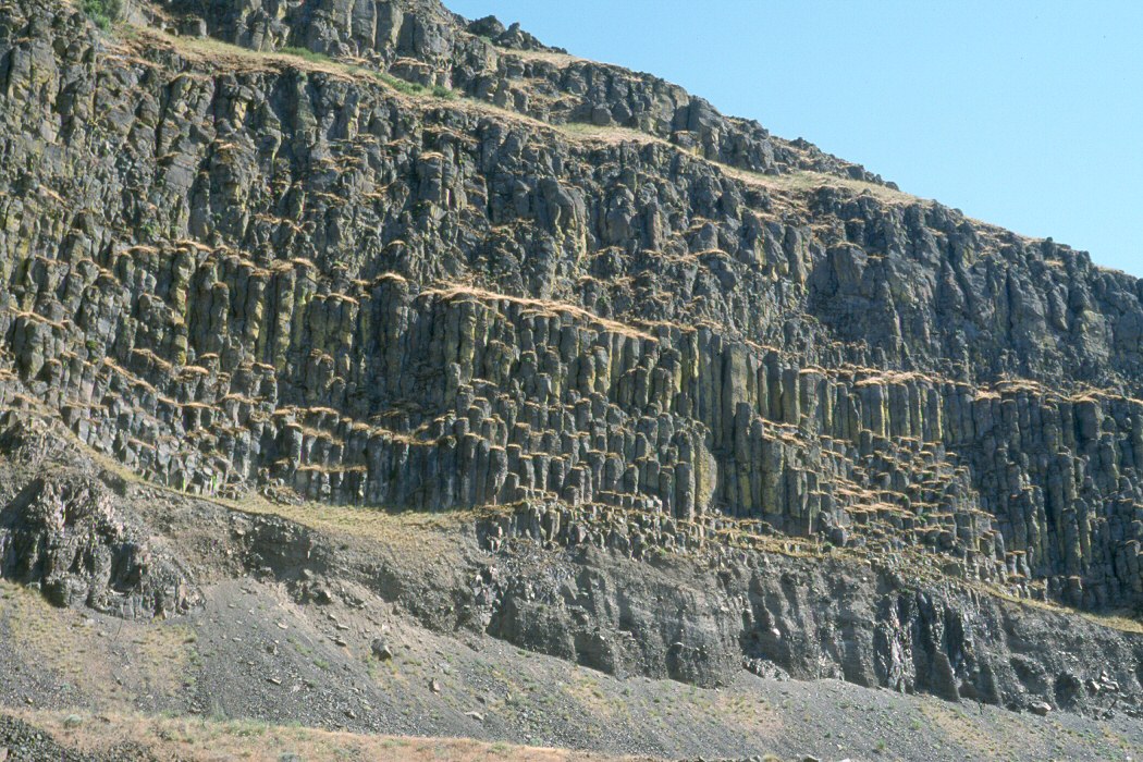
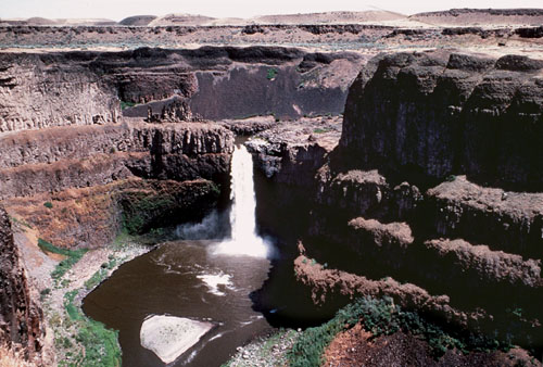
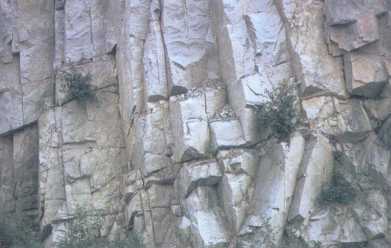
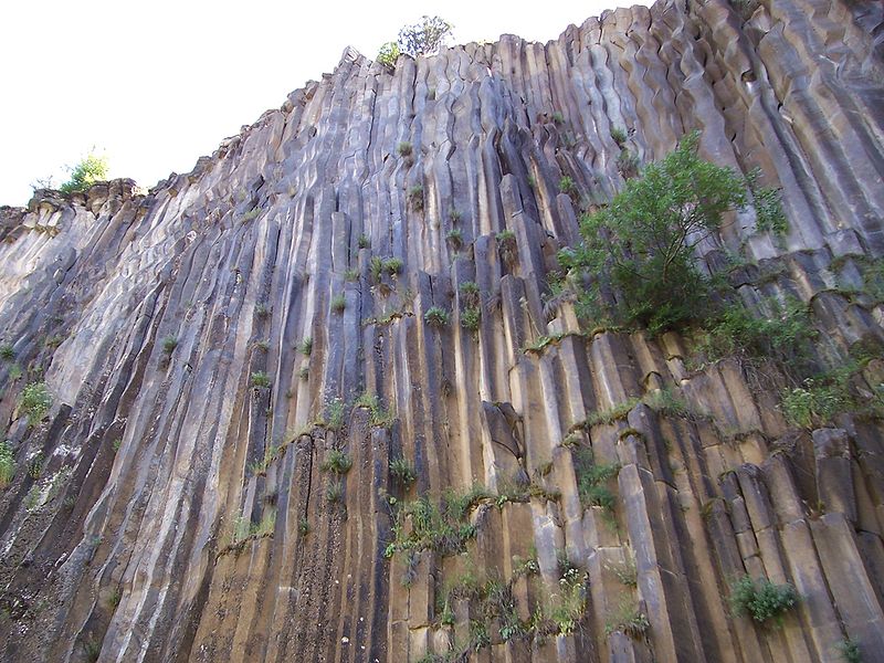
These rocks are usually distinctive in the field (out-of-doors). Igneous rocks are made from crystals - minerals that crystalized from once hot melts. Intrusive igneous rocks are commonly without notable layering - they can be described as massive, and result from cooling and solidification well beneath the Earth's surface. Granite is the most familiar intrusive rock type. Extrusive igneous rocks often occur in layers, which may vary in thickness, formed either by outflows of lava or accumulation of debris tossed into the air by erupting volcanoes. Basalt is the prevalent extrusive rock. Field examples of each are:
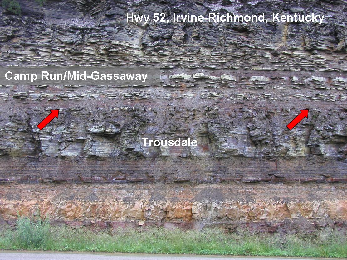
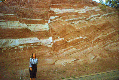
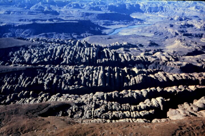
Sedimentary rocks are nearly always in layers. These are beds (also called strata) made up of deposits from the ocean or other water bodies that consist of clastic fragments (e.g., sand grains), or chemical or biochemical precipitates. Most frequently, the layers are initially laid down as horizontal units. The most common types of sedimentary rocks are shales, mudstones, sandstones, limestones, and evaporites (such as salt beds). If the strata are inclined (dipping), this usually means that the rocks have subsequently been pushed by mountain-building forces that have tilted or folded the units. Here are examples:
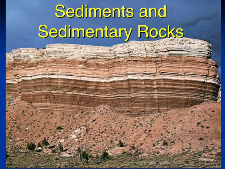
Shales are the most common sedimentary rock type, being made up of fine particles (mud is composed of such small particles). Shales are usually characterized by their tendency to break along thin layers called parting. Mudstones lack this feature. Here is a typical outcrop of shale beds:
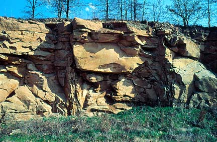
Sandstones are made up of sand-sized grains. Most common is quartz, the principal constituent of the thick sandstone beds seen below (graywackes are composed of sand fragments of eroded basaltic rocks; arkoses consist of fragments from granitic rocks)
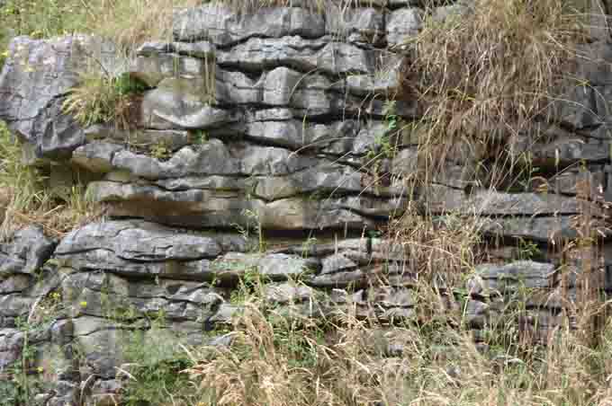
Limestones are the principal member of carbonate rocks. Typically, the limestone is a light whitish-gray, as seen in this outcrop:
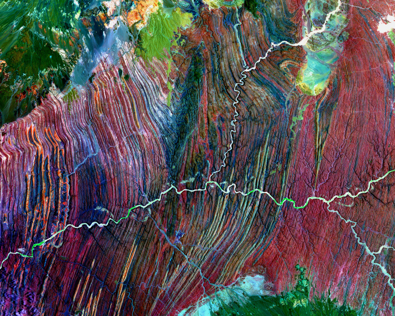
The bedding of sedimentary rocks is often conspicuous even when viewed from space, as shown by these limestone and sandstone units in Namibia.
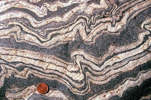
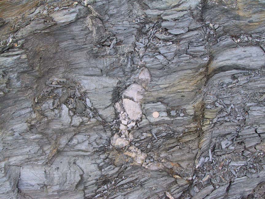
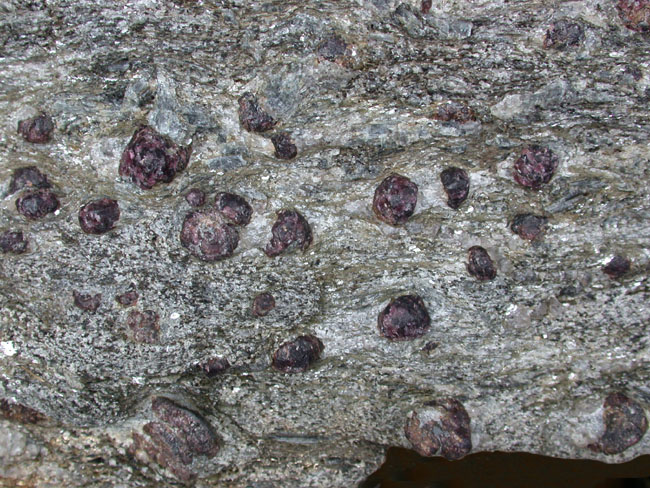
Metamorphic rocks result from the action of heat and pressure on pre-existing rocks (usually sedimentary) that are brought to depths of a few to tens of kilometers below the surface. New minerals are produced by this metamorphism. Shales (mudstones) may be recrystallized into mica-rich rocks called schists. As such rocks are heated to temperatures below but not far from those that would melt the rocks, they become soft, recrystallize further, and can be deformed into crenulated light and dark units that resemble layers, forming rocks called gneisses. Examples of slate, schist and gneiss are:
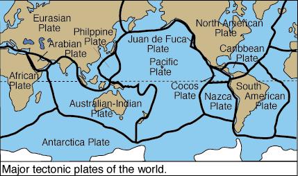
3. The Earth's outer shells (crust and upper mantle = lithosphere), about 150-200 kilometers thick under the continents (less so under the oceans), are subjected to dynamic forces that cause segments of the shells and materials at the top, to break up into plates and deposits on them that move laterally, bringing about deformation of their constituent rocks (mainly in and on the crust) by bending, folding, flowing, fracturing, movement of blocks along faults, and melting. The branch of geology that studies these deformational effects is known as Structural Geology. The dynamic processes, driven mainly by heat (much supplied by radioactive element decay) and gravity and resultant convection within and below the lithosphere (in the mantle), move plate units either away from each other or against each other (both situations can affect a plate); this general motion is called plate tectonics. Plates diverge from ridges rising from within oceanic basins (lower areas underlain by basaltic crust) and converge against boundaries of other plates (whose outer rocks are either oceanic or continental in nature and composition), causing melting, volcanism, metamorphism, mountain building, rise/fall of crustal blocks, continental growth and splitting.
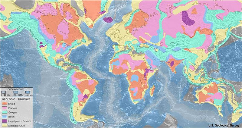
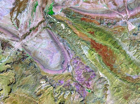
This next illustration has some of the inherent aspects of the plates within it. It shows however subdivisions of the continents in terms of structural settings that include 1) Shield (old igneous/metamorphic complexes; also called the craton); 2) Platform (supracrustal flat-lying sedimentary rocks); 3) Orogen (mountain belts; deformed rocks); 4) Basin (regions where sedimentary rocks have accumulated in geologically more recent times); 5) Large Igneous Province (areas of considerable cover by basaltic rocks); 6) Extended crust (parts of the continental crust now covered by marine waters).
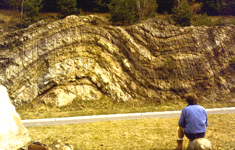
The previous two maps show large units of the Earth continental and oceanic crust. At much smaller scales, rocks within the plates are subjected to pressures that cause them to bend or break. This ground photo shows folds and a fault (where rock is broken and displaced).

The two principal types of bends (folds) appear in this photo - the upward arch (left) is called an anticline and the downward bend is a syncline. Folds are the result of compressive stresses (the rocks are "pushed" by external forces causing them to buckle or "wrinkle").
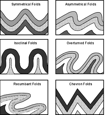
The geometry of folds gives rise to different descriptive terms that relate to the attitude of the limbs (either side) of the fold with respect to the horizontal (the inclination of linear or tabular features such as layers or strata is referred to as "dip"). These are the terms.
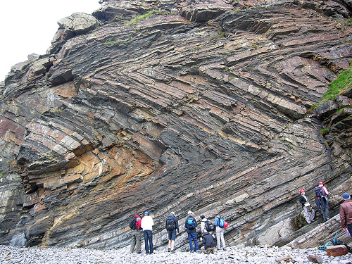
Here is a ground photo of tight (isoclinal) folding. The upfold on the left is an anticline; on the right is a downfold or syncline:
This is a recumbent fold ("lying on its side").
Folds tend to die out at either end as one looks down on them. This effect is called "plunging" and is illustrated here:
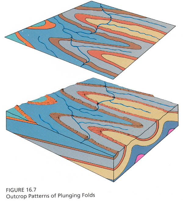
Note something else in this diagram. There is a general rule, the "Law of Superposition", that says younger layers of sedimentary rocks are laid down successively on top of older layers below. Note the sequence of strata in the diagram. In the anticline, the erosional surface (the horizontal plane) has produced a pattern in which the older rocks are interior to those on either side. The reverse is true for the syncline so that the younger rocks are interior. This hold for folds in general.
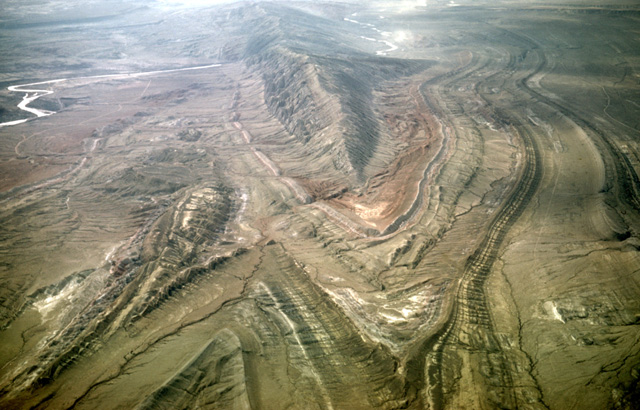
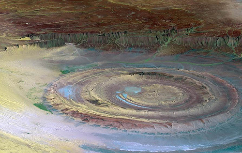
Here is an aerial view of a plunging anticline in Wyoming; below it is the surface of folded rocks with pronounced plunging as seen in a satellite image (the pattern can become complex):
As seen from the air, a circular to elongate anticlinal fold comprises a dome; the older strata are exposed in the center:
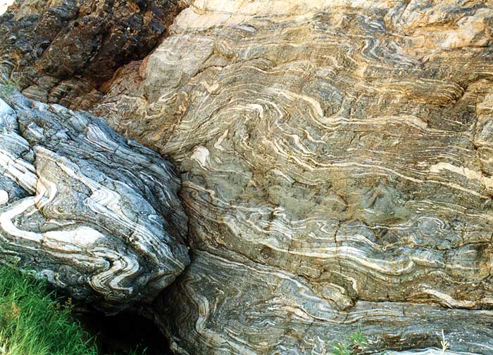
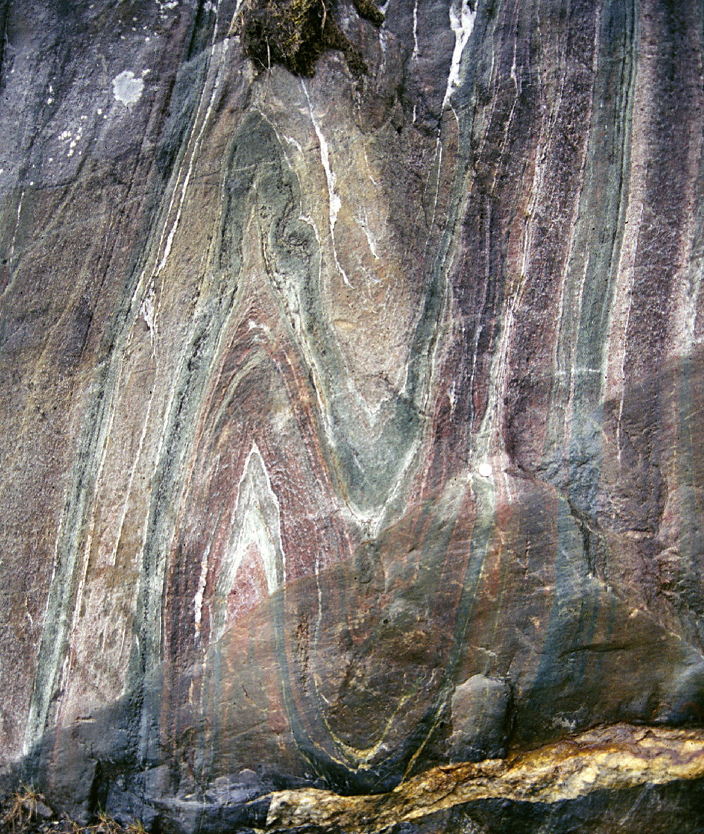
At a small scale (outcrop-sized), contorted folds are found in metamorphic rocks such as gneisses. The rocks actually soften (see below) as they are heated during deep burial. This type of folding, called ptygmatic, is illustrated here:
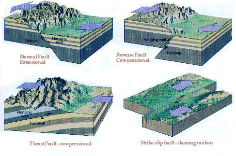
Faults result from rocks that are stressed (usually resulting in folding) that then break with rocks on either side of the fault plane being displaced (shifted) so as to create a discontinuity. Faults are given names that indicate the mode of stress and geometric nature of the displacement. The extensional (when the rock units are subject to tension stresses) fault is commonly known as a normal fault, the compressional type is called a reverse fault if the fault plane is high angle and a thrust fault if low angle; the transform fault is one type of wrench or rift faults that is associated with oceanic ridges.
A small fault is seen in this ground outcrop. The fault - a plane - appears as a line marking a discontinuity in the once continuous sedimentary layers. Rocks on the left side are displaced upwards:
Both a normal fault and a reverse fault are exposed at this outcrop.
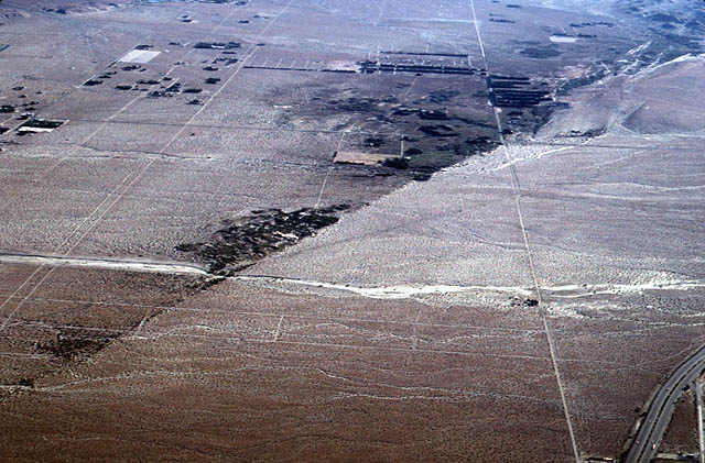
This fault can be recognized from the air as a line with dissimilar surface features on either side because the crustal blocks have shifted horizontally relative to each other; the movement is mainly horizontal making this a strike-slip fault.:
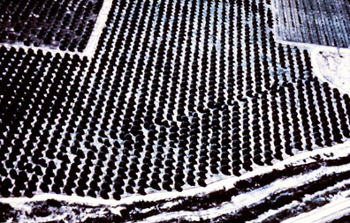
The most famous fault in North America is the San Andreas fault of California - another strike-slip fault. This reknown photo from the air shows offset of orange grove trees as the west side of the fault moved northward.
A thrust fault usually develops when an overturned fold breaks. Rocks are shoved up and outward such that older rocks are carried on top of younger (reversing the Law of Superposition), as shown here:
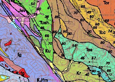
On a geologic map rock units are represented by different colors. In an area in which faulting has occurred, the fault trace at the surface is rendered as a black line; rock units on either side will show abrupt color mismatches:
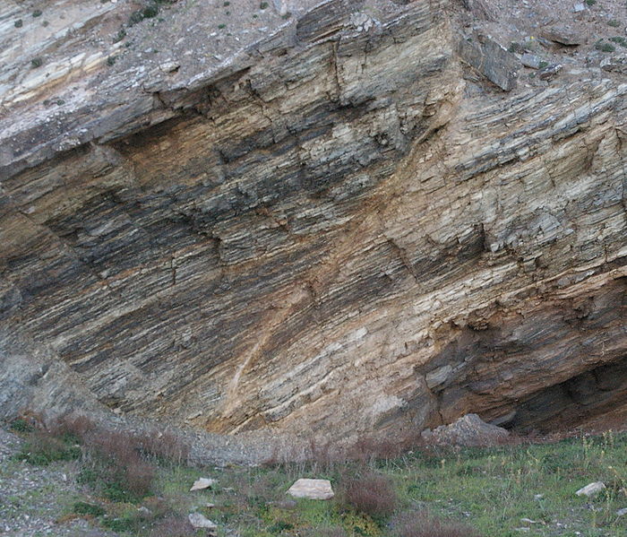
Rocks subjected to stress also can break without any displacement. These planar breaks (in effect, fractures) are called joints. Here are three examples:
A question may have crossed the reader's mind, to which we will now try to respond. Rocks when held in the hand or examined in the field that are struck with a hammer usually break into chunks, that is, they are brittle. How then can great masses of rocks, particularly those that are layered, bend and fold without breaking into bits? Several factors make up an answer. These are: confining pressure, heat, time, slow rate of deformation. All but the surficial rocks involved in mountain-building deformation are buried. Any individual part of the rock assemblage (imagine a cube of material) is confined by its neighboring rock masses. The rocks are subjected to heat from the Earth's interior and other sources. They are pressed upon by external forces (see next page). The pressures are exerted over long periods of time. Under these conditions rocks behave as though they were "soft" or ductile rather than brittle. (Metamorphic rocks that contort erratically are actually more like taffy than like hard rock.) They tend to deform at microscopic levels along atomic slip planes and a macroscopic levels along bedding planes. Slow deformation that produces folds takes millions of years as the rocks are gradually displaced. But at various stages the deformation may exceed the strength of the rock so that it does not bend but fractures instead and undergoes displacements along faults.
4. The distortions (lateral and/or with up-down movements) of crustal materials combine with physical and chemical reactions between atmospheric constituents (mainly oxygen and water) that weather (breakdown and/or dissolve) rocks which are then eroded, transported (by running water, ice, wind, gravity) and deposited in low surficial locations on land or in water bodies (oceans and lakes). These actions contiually modify the shape of the land and ocean surfaces producing a wide range of continental and oceanic landforms (mountains, valleys, plateaus, plains, volcanic edifices, etc.), developing a wide variety of landscapes.
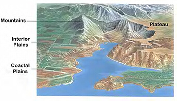
This illustration shows the four fundamental continental landforms:
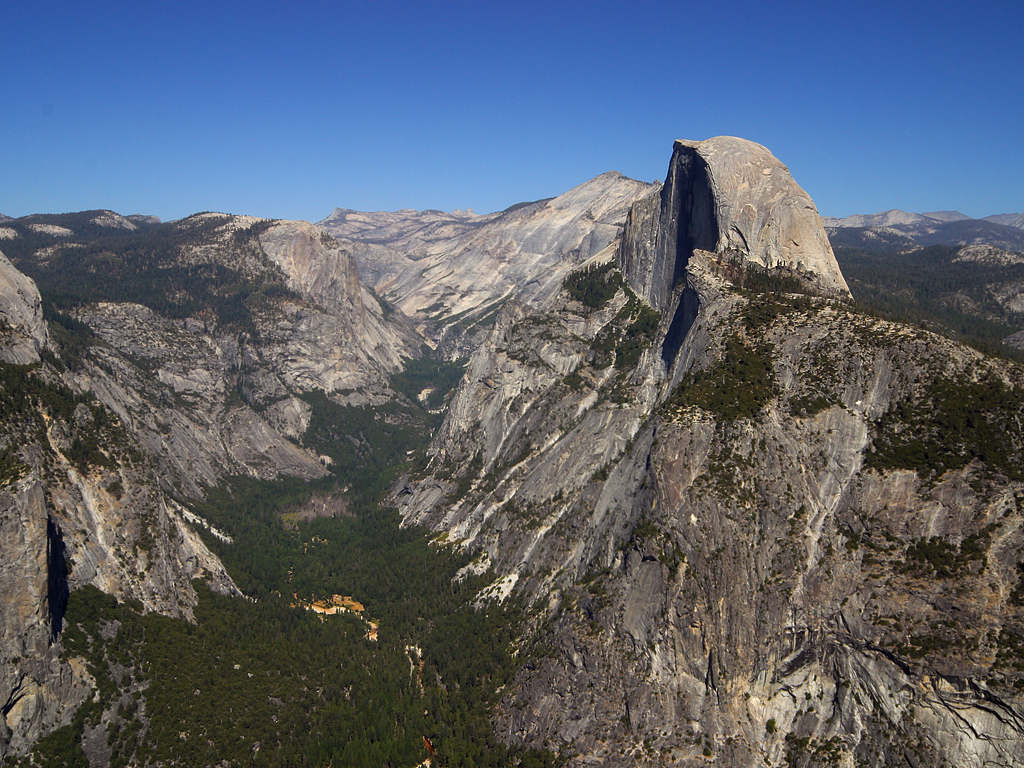
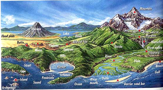
This is a panorama of many of the common landform types:
Landforms development is often a complex process requiring long time periods during which specific landform types take shape, evolve, and disappear. Factors involved, besides time, are the actions of shaping forces such as running water, etc., the type(s) of climate a region experiences (can change from humid to arid or reverse), the nature and resistance to erosion of the various rock type present and their structural configuration, the history of deformation over time, and rises and falls of the regional elevations (through isostasy - a tendency for the crust to assume altitudes that maintain balance [equilibrium] within the Earth's gravitational field). Modern theories of landform development are diverse but most trace their ideas back to 19th Century specialists (Geomorphologists) such as William Davis. While the details have changed, his notions of landform cycles remain largely valid. This illustration generalizes the changing landscape in a humid environment:
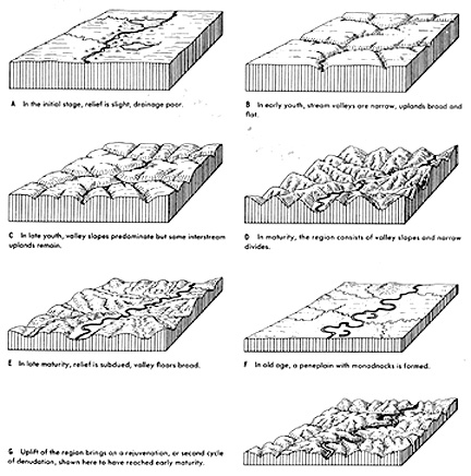
The starting point is the emergence of flat-lying sedimentary rocks from the sea as a coastal plain made up of flat-lying sediments. Streams that develop during Youth follow the gradient (slope) from the highest land to the ocean shoreline start to cut down narrow, steeper-walled valley slopes. The progression then is towards valley widening that leaves uplands as hills and mountains. By a stage called Maturity, the uplands have been carved by enlarging valleys so as to leave only the original uplands at narrow ridges. Thereafter, as Old Age is approached, gravity-driven erosion by sheet flow (thin spread of water over a surface) and by mass-wasting (loose rock movements) over the mountain surfaces slowly reduce these uplands to local hills with the landscape. The mountain terrain, having been generally lowered over time, finally becomes one of low relief (small differences in elevation). Davis called this end product a "peneplain", a term not now used except as an idealization of what a final stage would be like; uplift (block diagram G) is likely to occur before then, which causes a repeat of the overall process cycle (rejuvenation). If the rocks had been inclined (folded) rather than flat, the cycle would have been modified, with hard, less easily eroded rocks maintaining the upland mountains. Rejuvenation has now acted on the present-day Appalachian Mountains such that the ridges (see page 6-3) represent hard rocks and the valleys occur in softer, more easily removed rocks.
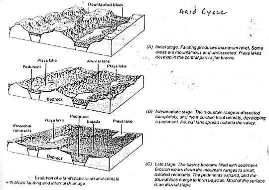
A different cycle can be specified for erosion under arid climatic conditions. The end result depends on the structural nature of an eroding region. One case, shown below, relates to mountains uplifted along high angle faults (producing "block-fault mountains") such as in the Basin and Range of the western U.S. (see page 6-8). Here the sequence of change seems simple: from the starting point of high mountains and low valleys, the mountains wear down and their eroded debris fill the valleys, so that the final outcome is a subdued topography with low remnant uplands (pediplains) and deeply filled, raised valleys.
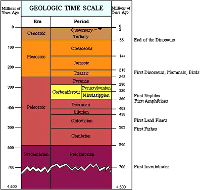
5. Since its beginning, the Earth has been an active, dynamic planet that experiences continual changes in its interior and especially its ouer lithosphere and surface. Its continents have grown relative to oceanic crust and have shifted in position (as referenced to a standard global surface) the movements are called continental drift. Most of Earth's history (expressed sequentially as the Geologic Time Scale) is best deciphered from its rocks, particularly sedimentary ones, that record sequences of modifying events (deduced in part through patterns of lifeforms [usually as fossils] changes (by evolutionary processes) and from rock age measurements (based on fixed rate radioactive decay).
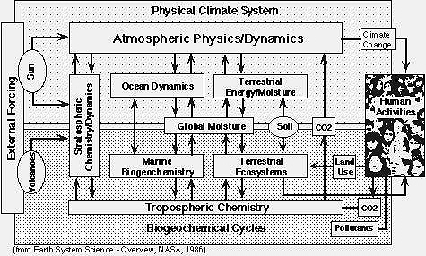
6. The Earth's surficial environments operate as a complex, interrelated system of units and features best categorized in terms of the physical/chemical components of the Geosphere. Atmosphere, Hydrosphere, and Biosphere powered by solar and internal heat that interact at, just below, and above the global surface to produce a series of conditions that aid, inhibit, and otherwise affect Humans and all living creatures. The study of how these "Spheres" interact, exchange energy, and produce positive and/or negative feedback is called Earth Systems Science. This version of the definitive Bretherton diagram suggests some of these inputs and effects.
In the remainder of this page, we will explore in more detail three primary topics: The Rock Cycle; Geologic Time; Plate Tectonics. The subject of Landscapes is more fully treated in Section 17, entirely devoted to Landforms from both ground and space prespectives.
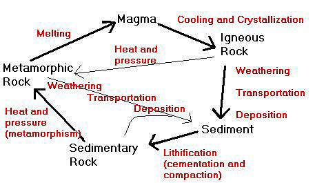
To discuss this subject, we will use these two diagrams; the first (similar to the one presented near the top of this page) shows again what is known as the Rock Cycle (observed changes from one rock type [and mode of origin] into other types) and the second indicates the names of the major rock types in each of the three main groups: Igneous; Sedimentary; Metamorphic:
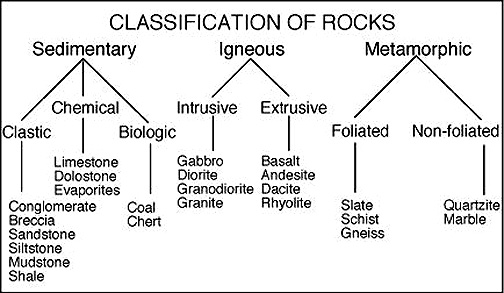
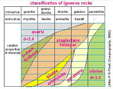
To assure you are certain of what a rock is, we define it simply as an assemblage of one or (most commonly) two or more minerals (specific chemical compounds) that form a part of the Earth's solid body. A "rock" normally connotes an individual "specimen" - one that can be held in one's hand or is larger but detached from its outcrop (exposure of the rock's source) so that it has visible boundaries. The dependence on mineral composition and texture in naming rock types is best illustrated as applied to igneous rocks, as in this diagram:
Key parts of the Rock Cycle (RC) involve magmatic/volcanic/metamorphic processes that produce crystalline rocks, the actions of water and air in disintegrating rock materials and transporting/depositing them as sediments which lithify into sedimentary rocks, the dynamic forces that deform rocks, and specialized actions like wind, waves, and ice in modifying rocks at the surface. The subsurface crust is altered by heat and pressure; the surface by physical/chemical weathering and erosion (W/E, namely Weathering/Erosion). Much of the RC is most active where tectonic plates meet: new rocks form; old rocks are changed.
The general pattern followed in the RC is shown in the first of the two diagrams at the beginning of this subsection. It can be summarized verbally in this sequence: Molten rock ---> Igneous Rock ---> W/E of igneous rock ---> Sediments ---> Sedimentary Rock ---> Sedimentary and Igneous Rocks, on burial, experience heat and pressure ---> Metamorphic Rock ---> further heating/pressure ---> Molten Rock. The process can then repeat. One added feature: any igneous, sedimentary, or metamorphic rock at/near the surface can undergo W/E ---> Sediment. The energy driving the RC comes from three principal sources: 1) Solar - the Sun's radiation provides kinetic energy to move air and water/ice; 2) Gravitational - rock and water movements downslope; 3) Thermal - trapped heat emanating mainly from the Earth's interior (where the source is radioactive decay) or from thermodynamic processes (compression, change of state).
Molten rock is called magma if it remains below the surface and lava if it reaches the surface. Most magma is generated in the crust (mainly upper lithosphere); some may derive from the uppermost mantle (asthenosphere) by upwelling and partial melting. Magma reaches the surface as volcanoes or volcanic outpourings primarily where 1) ocean plates spread (at ridges); 2) an oceanic plate dives under (subducts) another plate, inducing melting into magma that rises upward, often to the surface, 3) under continents that experience crustal or mantle heating (magma may remain below surface as batholiths), and 4) where a moving plate passes over a mantle thermal plume, causing a hot spot, and melting. The two main igneous rocks are Granite - which forms within continents, intrudes upwards but remains under the surface - it forms light-colored and large feldspar and quartz (minerals) crystals; and Basalt - which extrudes as lavas on both ocean floor and continental surface and rapidly cools - it is dark because of amphiboles/pyroxenes (greenish-black) with gray feldspars in small crystals.
Atmospheric weathering (H2O, O2, and CO2and near surface weathering mainly by water affect all rocks. Physical weathering - still and moving water, wind, gravity, and human activities - fractures, grinds, and flakes rocks into particles. Chemical weathering produces acid conditions that dissolves rock (example: sinkholes in limestone). Erosion loosens and moves particles (solids = clastics) and breaks rock down by solution. These become sediments that are transported by rivers, ocean waves, wind, sliding ice, gravity to collect in settling basins by deposition. Sediments tend to accumulate in layers and convert to sedimentary rocks by lithification - pressure squeezing (compaction) and cementing. Main sedimentary types are: Conglomerates/Breccias (pebbles and clasts [fractions of an inch up to boulders] held in a finer-grained matrix); Sandstone (visible grains of quartz, feldpsar)' Shales (fine particles including clay minerals), volumetrically the most common type; Limestones (chemical precipitates and biochemical animal/plant carbonates; and Coal (decayed plant matter).
Metamorphic ("changed form") rocks form from action of heat and pressure on pre-existing rocks. Shales (themselves finely layered) follow this progression with increasing T and P: Shale ---> Slate (fine-grained, brittle) ---> Schist (mica flakes) ---> Gneiss (light and dark crystal banding) ---> melting to a magma. Limestone ---> Marble; Sandstone ---> Quartzite; Basalt ---> Amphibolites or Serpentine. Most metamorphic rocks develop distinctive foliation or lineation; some may inherit evidence of layering if derived from sedimentary rocks.
CONTINUED ON THE NEXT PAGE.